AEA Training Venue Information
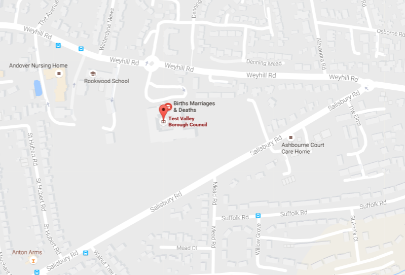
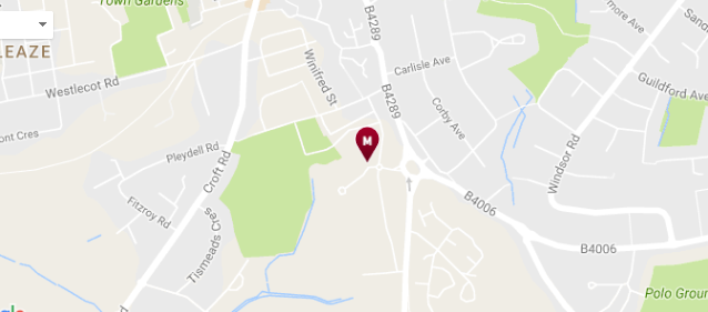
Andover
Venue: Beech Hurst, Weyhill Road, Andover, Hampshire SP10 3AJ
Venue Contact: Frances Cleland
Directions to Venue: http://www.testvalley.gov.uk – bottom left of main page (Andover address) for ‘View on Google maps’
Nearest Station: Andover Railway Station 10/15 minutes’ walk
Car Parking: Free car parking at venue, but please ensure that cars are parked in the parking area to the left of the main building (through the gap between wall and hedge) – although spaces cannot be guaranteed
Location Map
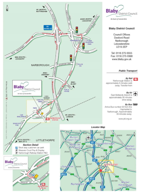
Blaby
Venue: Blaby District Council, Council Offices, Desford Road, Narborough, Leicester LE19 2EP
Venue Contact: Wendy Snart
Directions to Venue: See below
Nearest Station: Narborough, 2 minute walk
Car Parking: The customer car park is for short stay only (a maximum of 1 hour) and is free of charge. Alternative free parking for up to 2 hours is available for visitors in Weavers Court car park (adjacent to the Parish Centre on Desford Road) for which a ticket must be displayed. Longer stay can be purchased at the following rates – up to 3 hours £1, 4 hours £2.50, over 4 hours £4.50
Location Map
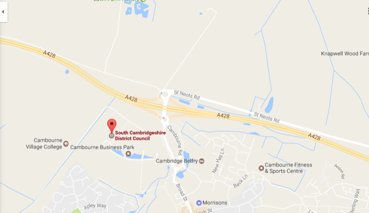
Cambourne
Venue: South Cambs District Council, Cambourne Business Park, Cambourne, Cambridge CB23 6EA
Venue Contact: Andrew Francis
Directions to Venue:
From the A1, (Northbound)
- Leave the A1 at the A428, St Neots exit and join the A428 towards Cambridge.
- After the roundabout junction with the A1198, leave the A428 and follow the signs for the Cambourne Business Park
From the A1(M), (Southbound)
- Leave A1(M) at junction 14 (signposted A14, (M11), London East, Huntingdon, Cambridge, Stansted) and join the A14.
- Stay on A14 for 6 miles. Exit A14 to join A1198 towards Royston and Papworth Everard.
- Remain on the A1198 to the roundabout junction with the A428 and turn left onto the A428.
- Leave the A428 and follow the signs for the Cambourne Business Park.
From the M11
- Leave the M11 at junction 13 and join the A1303 towards St. Neots / Bedford.
- Join the A428 and continue for a further 5 miles and then follow the signs for the Cambourne Business Park.
Nearest Station: St Neots or Cambridge 10 miles approximately
Car Parking: Free parking on site
Location Map
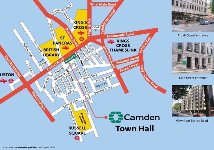
Camden
Venue: Camden Town Hall, Judd Street, London WC1H 9JE
Venue Contact: Saira McKechnie
Directions to Venue: See below
Nearest Station: Kings Cross/St Pancras, Euston (within 500m)
Car Parking: N/A
Buses: 10,17,30,45,46,63,73,91,205,390,476,
National Rail: Kings Cross, St Pancras, Kings Cross Thameslink, Euston
Location Map
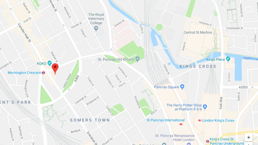
Camden – Crowndale Centre
Venue: Crowndale Centre, 218 Eversholt Street, London, NW1 1BD
Venue Contact: Saira McKechnie
Directions to Venue: Crowndale Centre is opposite Mornington Crescent tube station or a 5 minute walk up from Euston Station.
Nearest Station: Kings Cross, St Pancras, Kings Cross Thameslink, Euston
Car Parking: N/A
Location Map
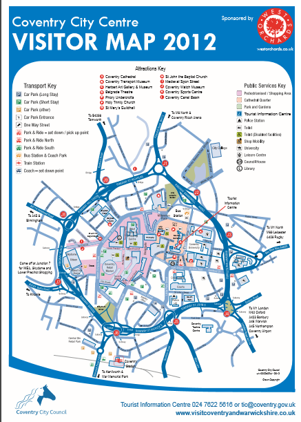
Coventry
Venue: The Council House, Earl Street, Coventry CV1 5RR
Venue Contact: Jade O’Hara
Directions to Venue: https://www.coventry.gov.uk/directory-record/50249/council-house
Nearest Station: Coventry 10 min Walk
Car Parking: See map below
Location Map
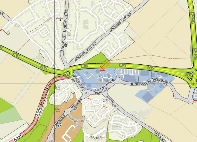
Dover
Venue: Dover District Council, Council Offices, Whitecliffs Business Park, Whitfield, Dover, CT16 3PJ
Venue Contact: Louise Cooke
Directions to Venue: By Road, Offices located in Business Park immediately adjacent to the A2 at Whitfield, Dover. Access to Dover via M2 or M20
Nearest Station: Train to Dover Priory. 1hr 7 min from St Pancras on HS1, Approx 1hr 50 mins from Victoria Journey time from station approximately 10 minutes.
Car Parking: Car Parking available at Council Offices. Additional Parking available in the Staff Car Park on the access road immediate opposite to the Offices.
Location map
Gedling
Venue: Gedling Borough Council
Directions to Venue: Coming From The M1, Junction 26 (A610). Leave Motorway (signposted Nottingham) and at roundabout take 1st exit A610. Junction with A6002/B600. At roundabout take 3rd exit if entering from the South, and the first exit if entering from the North. Junction with B6008. At roundabout forward (signposted City Centre). Junction with A6514. At traffic signals turn left A6514 (not shown) into Nottingham Ring Road (signposted Ring Road, Mansfield A60). Junction with A611. At roundabout take 2nd exit. In 0.4 miles, at roundabout take 2nd exit. “The Vale” public house (Junction with A60). At the set of traffic signals turn left. Carry straight on until you reach the third set of traffic lights. Turn right into Nottingham Road. We are on the second turning on your right.
Location map

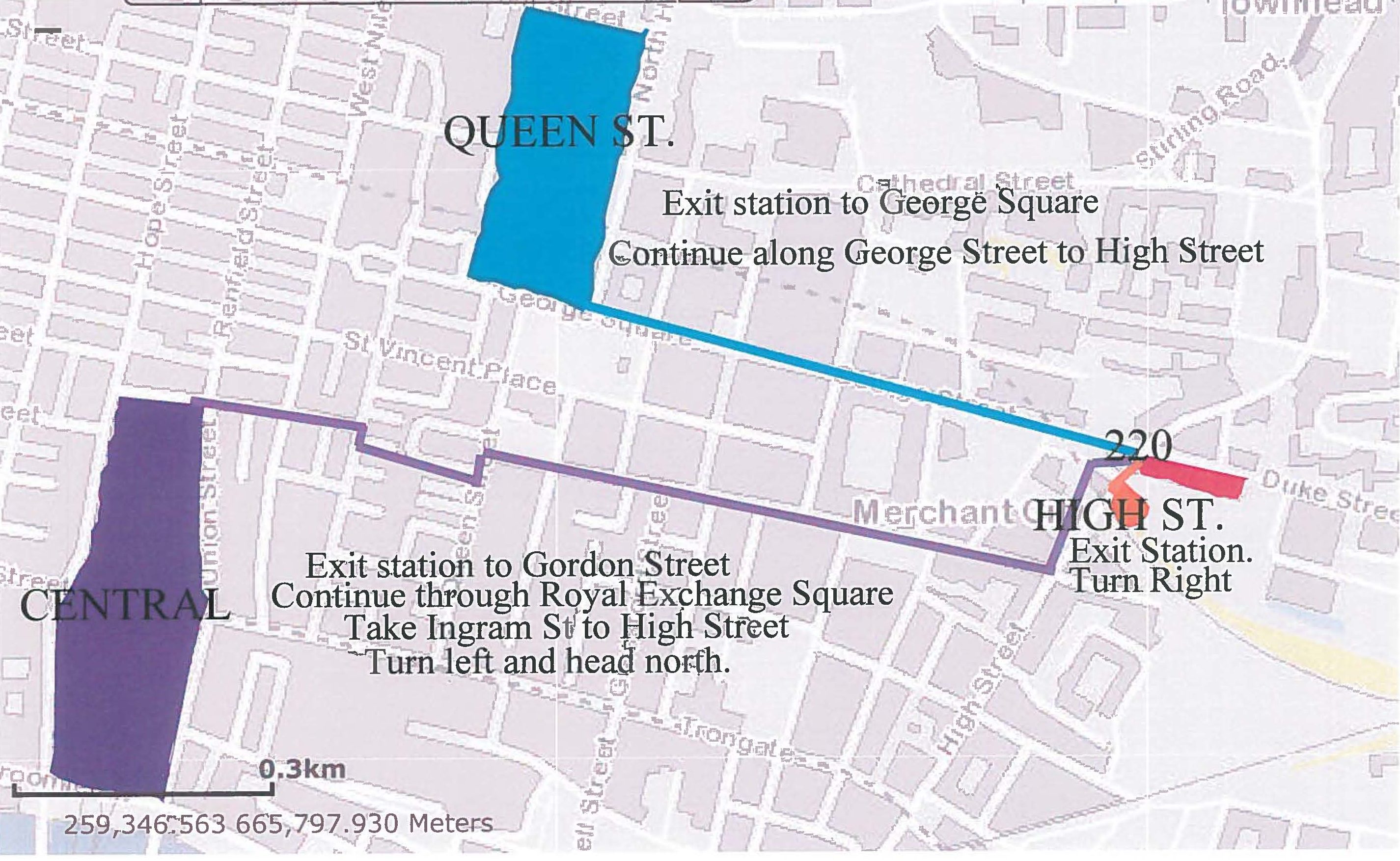
Glasgow
Venue: Glasgow City Council
Directions to Venue: See below
Location map
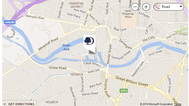
Leeds
Venue: Double Tree by Hilton Hotel Leeds City Centre, Granary Wharf, 2 Wharf Approach, Leeds, LS1 4BR
Venue Contact: Double Tree Leeds City Centre
Nearest Station: Leeds City Station
Car Parking: £19.00 (day only: £9.50)
Milton Keynes
Venue: Delta by Marriott Milton Keynes, Timbold Drive, Kents Hill Park, Milton Keynes, MK7 6HL
Directions to Venue: At junction 13 of the M1, take the A421 exit to Milton Keynes. Keep left and at the roundabout, take the 2nd exit. In two miles, at the roundabout, take the 1st exit onto A421 and stay on A421 for 3 miles. At the roundabout take the 2nd exit onto Groveway, stay on Groveway for 2.5 miles until the right turn onto Timbold Drive. The hotel will be on your left in 400 ft.
Nearest Station: Milton Keynes
Car parking: Free on site parking
Neath Port Talbot
Venue: Neath Port Talbot Civic Centre
Venue Contact: TBC
Directions to Venue: See below
Location map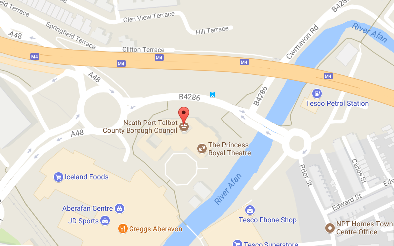
Nottingham
Venue: Double Tree by Hilton Nottingham – Gateway Hotel
Venue Contact: Double Tree by Hilton Nottingham – Gateway Hotel – TEL: 0115-9794949
Directions to Venue: The hotel is situated on the A610, 3 miles from Nottingham City Centre, 1 mile from Junction 26 of the M1 motorway. For satellite navigation systems our post code is: NG8 6AZ.
Nearest Station: Nottingham
Car Parking: Free on site parking.
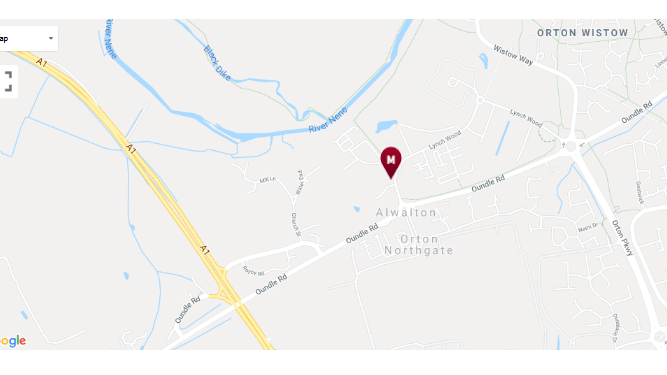
Peterborough
Venue: Peterborough Marriott Hotel, Peterborough Business Park, Lynch Wood, Peterborough, England PE2 6GB
Venue Contact: Marriott Hotel Peterborough
Directions to Venue: See below
Nearest Station: Peterborough
Car Parking: Complimentary on-site parking
Location Map
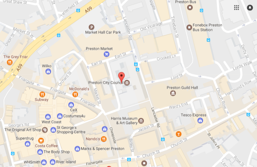
Preston
Venue: Town Hall, Lancaster Road, Preston, PR1 2RL
Venue Contact: Theresa Palin
Directions to Venue: See below
Nearest Station: Preston station, 10/15 mins walk
Car Parking: Bus station (5 mins walk away) – Pay & Display £4 per day
Location Map
Swindon
Venue: Swindon Marriott Hotel, Pipers Way, Swindon SN3 1SH
Venue Contact: Marriott Hotel
Directions to Venue: The Swindon Marriott Hotel is situated in the Old Town, close to Junction 15 of the M4 motorway with easy access to all areas within the town. Easily accessed by road with the closest railway station being Swindon station, it is approximately 7 miles and 20 minutes in a taxi.
Car Parking: Complimentary on-site parking
Location Map
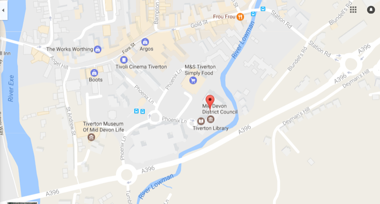
Tiverton
Venue: Council Chamber, Phoenix House, Phoenix Lane, Tiverton EX16 6PP
Venue Contact: Jackie Stoneman
Directions to Venue: Exit at junction 27 of the M5, take the 3rd exit onto the A361 (signposted Barnstaple, Tiverton)
About 7 miles along this road, take turning signed Bickleigh and Tiverton.
Turn left at top of slip road.
Straight across next roundabout. (Macdonalds is on your left). It is signposted Town Centre.
3rd exit from next roundabout (signposted Town Centre, Bickleigh) At next roundabout take the 1st exit (also signposted Bickleigh).
At next roundabout take the 3rd exit onto Phoenix Lane and multi-storey car park in on your right. The Council office is right next to the multi-storey (big glass building)
Nearest Station: Tiverton Parkway station is about 7 miles outside the town so you will need to get a bus or taxi from the station.
Car Parking: Multi-storey next door (Phoenix Lane), £1 for 5 hours
Location Map
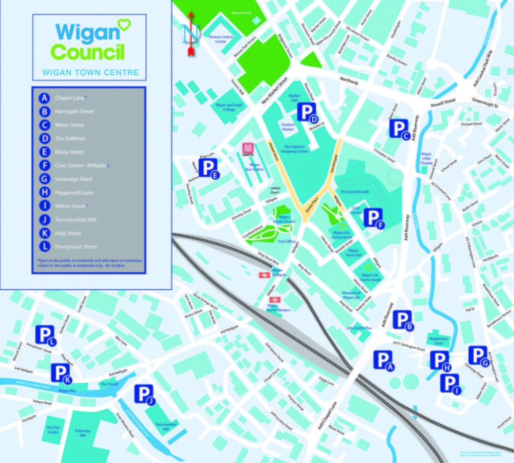
Wigan
Venue: Council Chamber, Wigan Council, Wigan Town Hall, Library Street, Wigan, WN1 1YN
Venue Contact: Julie Baron
Directions to Venue: See map below
Nearest Station: Wigan Wallgate 5 Minutes walk to Town Hall, Wigan North Western 5 Minutes Walk to Town Hall
Car Parking: https://www.wigan.gov.uk/Resident/Parking-Roads-Travel/Parking/Car-parks-and-charges/Car-park-and-permit-charges.aspx
Location Map
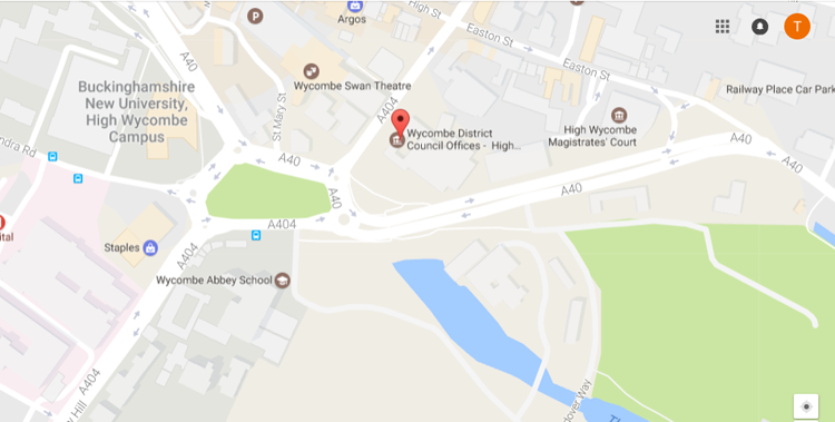
Wycombe
Venue: Wycombe District Council, Queen Victoria Road, High Wycombe, Bucks HP11 1BB
Venue Contact: Fiona Blackett
Directions to Venue: https://www.wycombe.gov.uk/pages/About-the-council/Contact-and-payments/Council-offices.aspx
Nearest Station: A five minute walk from High Wycombe railway station
Car Parking: https://www.wycombe.gov.uk/pages/About-the-council/Contact-and-payments/Council-offices.aspx
Location Map
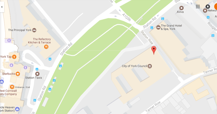
York
Venue: West Offices, Station Rise, York YO1 6GA
Venue Contact: Andrew Flecknor
Directions to Venue: Located on Station Rise opposite the Cedar Park Hotel, entrance via the Toft Green public entrance. Located close to Park and Ride stops for Monk Bar, Askham Bar and Rawcliffe Bar: https://www.york.gov.uk/directory-record/444/york-park-ride-sites
Nearest Station: York, 200 metres
Car Parking: None at venue unless disabled badge holders confirmed in advance. NCP car park located on same street at Tanner Row : http://www.ncp.co.uk/find-a-car-park/car-parks/york-tanner-row/
Public car parks close by at Esplanade Car Park five minutes, Nunnery Lane and Marygate, both ten minutes: https://www.york.gov.uk/CarParks
Location Map
York
Venue: DoubleTree by Hilton York, St Maurices Road, York, YO31 7JA
Directions to Venue: Located on Maurice Road York directions can be found here,.
Nearest Station: York
Car Parking: Chargeable parking on site.